The project will focus on an area of the Kings Beach community that is currently served by undersized backyard watermains dating to Kings Beach’s earliest development. The new watermains will enhance the neighborhood’s hydrant coverage and will improve available fire-flow from less than 200 gallons-per-minute to greater than 2,500 gallons-per-minute after project completion.

This project includes approximately 2,600 feet of new watermain, 61 residential water services, and five new fire hydrants.

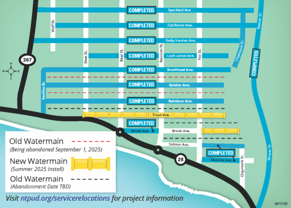
Construction on Trout and Brook Avenues is scheduled to begin on Monday, July 7 and continue through October 2025.

Estimated Cost: $1,715,680

Estimated Complete Date: October 2025


PROPERTY OWNER SERVICE RELOCATIONS

Detailed information for property owners is available via this link – Kings Beach Waterline Service Relocations

  • Property owners currently served by an old watermain in a backyard easement will be required to relocate their water service and connect to the new watermain.
  • The District will install a new point of connection (meter box and customer shut-off valve) at the property line facing the street; however, the construction of the new water service from the building to the new point of connection is the responsibility of the property owner, as outlined in NTPUD Ordinance #361.

The Deadline for impacted properties on Trout, Brook, Salmon, Chipmunk, and Rainbow Avenues is September 1, 2027. 

Kings Beach Waterline Service Relocations


Overview:

This map displays the status of old and new water main installations and abandonments in a residential area managed by the North Tahoe Public Utility District (NTPUD). It focuses on several east-west streets between Highways 267 and 28, with status indicators for construction projects and infrastructure updates. The map also highlights specific roads where water main work has been completed or is planned.

Geographic Orientation:

  • North is at the top of the map, indicated by a compass rose in the lower left.
  • Highway 267 runs vertically on the left (west) side of the map.
  • Highway 28 runs horizontally near the bottom of the map, curving around the bottom-right corner.
  • Streets run east-west between these two highways, with vertical residential streets intersecting them.

Project Status:

The map shows three types of water main infrastructure:

  1. Old Water Main (being abandoned on September 1, 2025)
    • Shown as red dashed lines
    • Present along Steelhead, Golden, and Rainbow Avenues.
  2. New Water Main (to be installed in Summer 2025)
    • Shown as solid yellow lines with pipe icons
    • Planned along Trout Avenue, Brook Avenue, and an unnamed road near Chipmunk Street.
  3. Old Water Main (abandonment date to be determined)
    • Shown as black dashed lines
    • Present along Brook Avenue, Brook Avenue east of Chipmunk Street, and other connecting segments.

Streets with Completed Projects:

Each of the following streets has a blue box labeled “COMPLETED” next to it, indicating that water main installation or relocation work is finished:

  • Speckled Avenue
  • Cutthroat Avenue
  • Dolly Varden Avenue
  • Loch Levon Avenue
  • Steelhead Avenue
  • Golden Avenue
  • Rainbow Avenue
  • Trout Avenue
  • Brook Avenue
  • Minnow Avenue
  • Beaver Street (on the right/east side of the map)

The vertical streets intersecting these include Wolf Street, Deer Street, Bear Street, Raccoon Street, Fox Street, Chipmunk Street, and Beaver Street.

Additional Notes:

  • The main roads used for access are Secline Street on the west and Beaver Street on the east.
  • A black line running horizontally near the bottom of the map represents existing or active infrastructure routesalong Highway 28 and nearby areas.

Legend (Located Bottom Left):

  • Old Watermain (being abandoned September 1, 2025) is shown as red dashed lines.
  • New Watermain (Summer 2025 install) is shown as yellow pipe segments.
  • Old Watermain (abandonment date to be determined) is shown as black dashed lines.

Contact and More Information:

For up-to-date project details and service information, residents are directed to visit the webpage:
ntpud.org/servicerelocations

Date of map: April 11, 2025

Recent Posts