Overview:
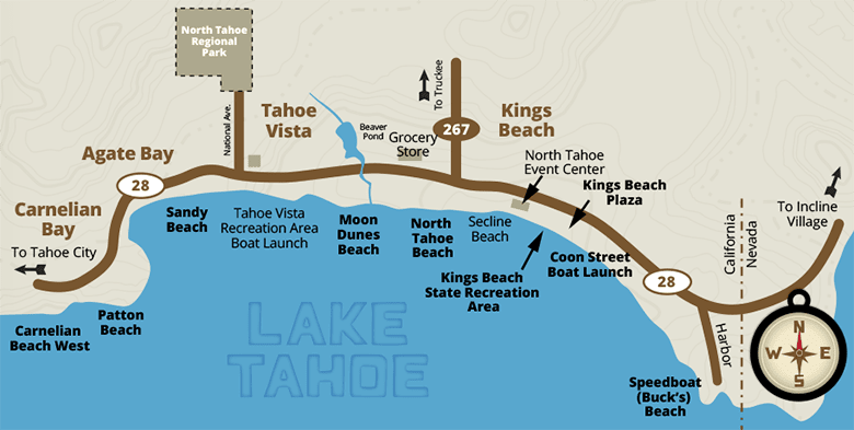
This map provides a simplified view of the northern shoreline of Lake Tahoe, highlighting beaches, recreational areas, boat launches, and key roads between Carnelian Bay and Incline Village. Highway 28 and Highway 267 are shown. North is oriented to the upper right corner.
Geographic Coverage:
The map spans from Carnelian Bay in the west through Tahoe Vista and Kings Beach, and toward Incline Village on the east, marking notable lake access points and local roads.
Roads and Orientation:
- Highway 28 runs along the lake’s edge from west to east.
- Highway 267 branches north from Kings Beach toward Truckee.
Beach and Recreation Locations (west to east):
- Carnelian Beach West – Located in Carnelian Bay.
- Patton Beach – Just east of Carnelian Bay.
- Sandy Beach – In Tahoe Vista.
- Tahoe Vista Recreation Area Boat Launch – Public boat access point.
- Moon Dunes Beach – East of the boat launch.
- North Tahoe Beach – Along the shoreline before Kings Beach.
- Secline Beach – Located near central Kings Beach.
- Kings Beach State Recreation Area – A large beach and day-use park.
- Coon Street Boat Launch – A second boat ramp in Kings Beach.
- Speedboat (Buck’s) Beach – Near the California-Nevada border.
Landmarks and Facilities:
- North Tahoe Regional Park – Inland, near Tahoe Vista.
- Beaver Pond Grocery Store – Shown near Tahoe Vista.
- North Tahoe Event Center – Located in Kings Beach.
- Kings Beach Plaza – A central gathering and shopping area.
Direction Labels:
- To Tahoe City – West along Highway 28.
- To Truckee – North via Highway 267.
- To Incline Village – East past Speedboat Beach.
- California/Nevada border – Marked near eastern edge.
Compass Notes: North is oriented to the top-right, with the shoreline running roughly west to east. The lake lies south of the beaches.
Call (530) 546-4212 for more information.

